
Why the Bridgwater Tidal Barrier Scheme Matters
The Bridgwater Tidal Barrier Scheme will protect over 11,300 homes and 1,500 businesses from tidal flooding.
While the existing flood defences in Bridgwater and downstream are doing their job for now, the risk of tidal flooding is increasing. Just over 10 years ago, a combination of high tides and river flows nearly led to severe flooding in the town. Without this Scheme, rising sea levels and storm surges would place Bridgwater and surrounding communities at increasing risk of flooding.
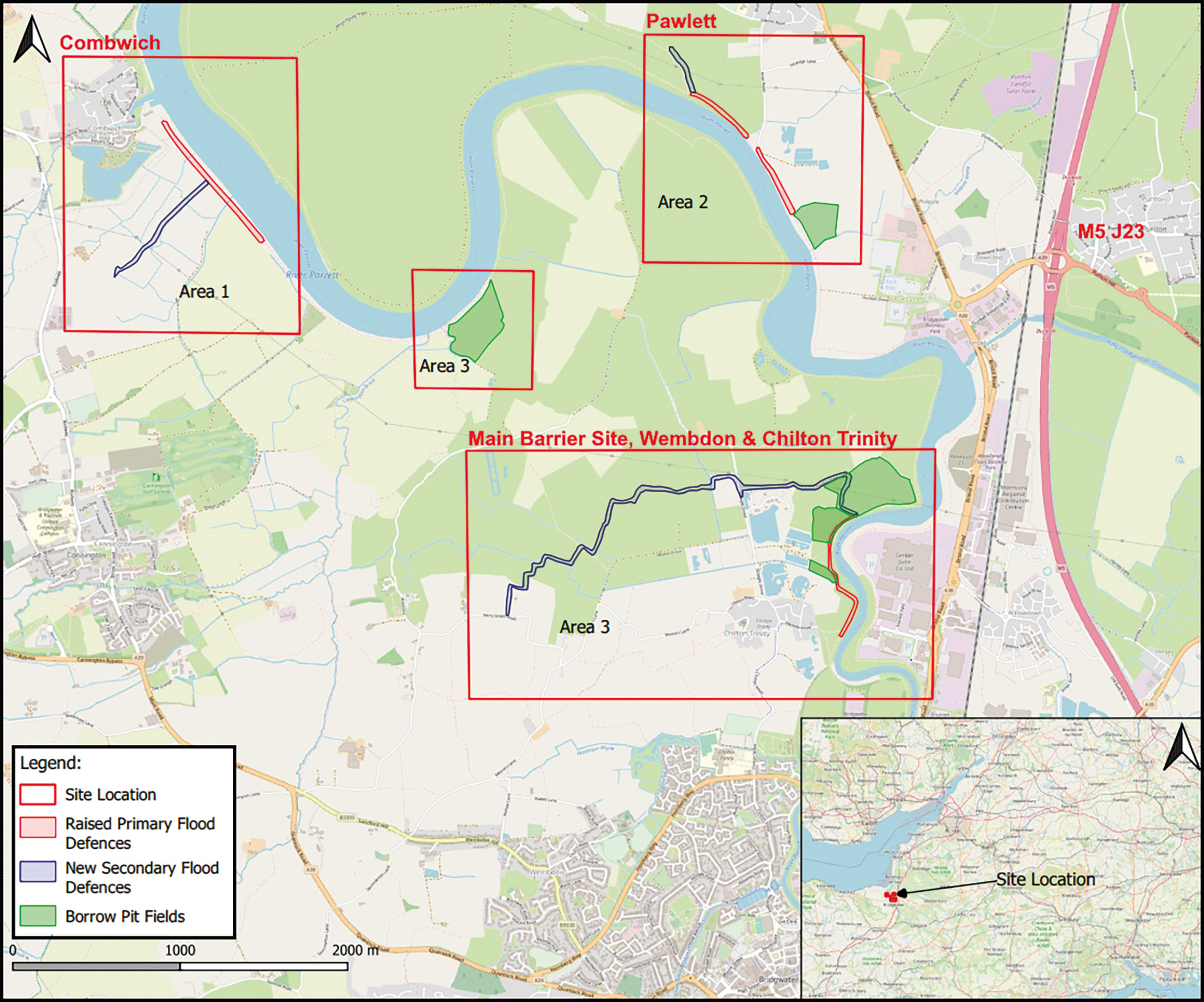
Flood defences will be required downstream of the barrier to prevent flood water bypassing the barrier and to better protect the villages of Combwich, Chilton Trinity and Pawlett, the A38, the railway and farmland. We will do this by improving the existing flood defences and building new secondary defences.
Villages protected by the River Parrett flood banks are low lying, with some areas lower than 7 metres Above Ordnance Datum (AOD) and much of the area below 8 metres AOD . In Bridgwater Bay, and hence in the River Parrett, the 1 in 20-year extreme tide level is fast approaching 8 metres AOD . In 100 years, it will be nearly 9 metres AOD .
Not only must our local operatives continue to maintain the existing flood banks, but we also have to raise and improve the banks where needed to keep ahead of the rising tide levels.
Without these essential works the banks would overtop or breach, and the whole area would be at risk of filling up with tidal waters, potentially to depths of up to 1 to 2 metres.
Each year, around 700 flood events are recorded in England, causing £2.4 billion in damages to homes, businesses, and infrastructure. Without action, these costs could rise to £3.6 billion annually by 2050. Therefore, investing in flood defences is one of the smartest things we can do.
- The Bridgwater Tidal Barrier Scheme will deliver a 1 in 200-year standard protection up to 2125 for the town of Bridgwater, and up to 2055 for the communities of Combwich, Chilton Trinity, and Pawlett.
- The proposed design of the Scheme will ensure that the flood defences are able to adapt to climate change over the next 100 years, allowing it to cope with the expected rise in sea level during this time of 0.75 to 1 metre.
- The Scheme comprises more than just a barrier; the Bridgwater Tidal Barrier Scheme includes new and improved downstream flood defences and better fish and eel passage at up to 12 key locations, creating a resilient, thriving future for Bridgwater.
The impact of flooding is far reaching, it’s about homes, businesses, schools, roads and lives being disrupted significantly with a great emotional, physical and financial impact, that can take years for individuals and communities to recover from.
The project comprises three workstreams
Workstream A: Construction of a tidal barrier near Express Park
The operation of the barrier will see it closed at low water for 4 to 6 hours to manage surge tides if the tide is forecast to exceed a pre-agreed level in Bridgwater. It will be operated up to twice a month for maintenance and training purposes, and initially up to 5 times a year for flood management. The frequency of operation will increase as sea levels rise, possibly up to 55 times per year by 2126. Operating the barrier will not increase fluvial flood risk to lives and homes along the River Parrett. At high river (fluvial) flows there will be an upstream benefit in excluding surge tides.
Workstream B: Upgrading and building new flood banks downstream near Chilton Trinity, Combwich, and Pawlett
Flood defences are required downstream of the barrier to prevent flood water bypassing the barrier and to better protect the villages of Combwich, Chilton Trinity and Pawlett, the A38, the railway and farmland. We are improving the existing flood defences and build new secondary defences.
Some of the downstream defences are currently modelled to around 2055 because:
- Climate projections show increased tidal levels and surge frequency beyond 2055, and by then we will have more confidence in the scale of changes.
- These defences have been intentionally designed to be adaptable, allowing future raising or strengthening if required.
This approach allows investment to be phased sensibly, while still maintaining protection and avoiding over-engineering too early.
Importantly, 2055 is not a stop date. The defences will continue to function beyond this point, but future assessments may recommend enhancements to maintain the same level of flood protection.
Workstream C: Enhancing fish and eel passage at up to 12 upstream sites on the Rivers Parrett and Tone.
As part of the Bridgwater Tidal Barrier Scheme, we are delivering improvements to up to 12 fish and eel passes across the Rivers Parrett and Tone. These upgrades will help migratory species reach the habitats they depend on to thrive.
We are delivering these passes in a phased programme, aligned with the construction of the tidal barrier and downstream defences. Although the barrier will only begin to significantly affect fish migration from around 2055, we are introducing these improvements earlier to maximise ecological benefit and ensure healthy, resilient fish populations well into the future.
Our priority remains the long-term health of the river system, improving connectivity, biodiversity, and habitat quality for decades to come.
There are also upstream benefits. The barrier will close ahead of high tide while river levels are still low, creating additional capacity in the river upstream for the fluvial flows.
We will be on site for another 5 to 6 years and are working at pace to get the barrier structure operational as a priority. Work will then continue on the wider site, including final downstream defences, landscaping, and riverside enhancements, towards full Scheme completion.
This phased approach delivers early flood protection to Bridgwater and surrounding communities, while ensuring a lasting legacy of environmental and public benefit.
The timeline allows the team to deliver the Scheme to the highest standards of safety and quality, while integrating key environmental and community features, such as:
- Improved Public Rights of Way (PRoW) and active travel routes along the River Parrett
- A new foot and cycle bridge across the River Parrett
- Public spaces at the barrier
- Around 4 hectares of new wetland habitat from borrow pits
Together, these features help safeguard the area, support sustainable growth, and boost business confidence.
Map of Bridgwater Tidal Barrier site location
Our vision
Bridgwater Tidal Barrier – December 2025
We are excited to share our 2025 End of Year Video, highlighting progress across all eight flight paths. Featuring new footage and quarterly highlights, it shows how far the Bridgwater Tidal Barrier Scheme has advanced in 2025.
2025 has seen major on-site activity, design refinements, community events, site visits, and important ecological, environmental, and archaeological work. It has been a year of teamwork, innovation, and problem-solving.
Looking ahead to 2026, we are excited to continue this momentum and partnership as we deliver the next stages of this vital flood risk reduction scheme.
Bridgwater Tidal Barrier Scheme 4D Animation
Spring to Autumn 2025 Construction Progress. See the Barrier start to come to life.
Here we highlight the key steps in preparing the construction site for the substructure of the Tidal Barrier. To enable work on the barrier itself, the River Parrett must first be temporarily diverted around the site via a by-pass channel. Watch the animation to see how this vital stage is achieved.
Our goals
- Reduce Flood Risk – Lower tidal flood risk for 11,300 homes, 1,500 businesses, and future developments will significantly reduce the impact of damage to building and infrastructure and to injury and loss of life. This Scheme will also help facilitate further growth and regeneration in Bridgwater.
- Strengthen Defences – Upgrading flood defences will prevent structural damage and collapse, mitigating rapid flooding from overtopping.
- Climate Resilience – Investing and future-proofing flood management assets for 100 years, accommodating expected sea level rise.
- Community and Biodiversity Enhancements – Providing new public amenities, including a foot and cycle bridge, improved public spaces, and the creation of 14 hectares of wetland and 11 hectares of open water and the creation of borrow pits.
- Sustainable Investment – Reducing carbon footprint by using local borrow pits and photovoltaic panels, supporting carbon reduction targets and the UN Sustainable Development Goals.
Why we need the Scheme and how it will work
The Bridgwater Tidal Barrier Scheme is a vital, forward-looking investment in how the town manages flood risk in a changing climate. Rather than just protecting a fixed number of homes, it safeguards essential services, supports local economies, and enables sustainable growth across the area.
With sea levels projected to rise by up to one metre over the next 100 years and more frequent extreme weather events, the Scheme offers long-term protection and resilience. It will operate into the next century, reducing flood risk while enhancing public spaces and environmental health.
The Scheme also brings lasting community benefit through improved access and connectivity. A new foot and cycle bridge will cross the River Parrett as part of the barrier, linking to the Parrett Trail and a new cycleway running from The Drove along Barrier Way, originally built to support early construction works.
You can find out what has been achieved to date by reading our newsletters.
Habitat and Biodiversity
As work continues on the BTB Scheme, project teams are constantly balancing the demands of construction with the rhythms of nature, the tides, and the changing seasons.
We have found several important animal species across various areas of the scheme. These include species of bat, reptiles and birds, as well as great crested newts, water vole, otters and badgers. All these species are protected by law, and we are working with our biodiversity specialists, Natural England and ecologists at Somerset Council to ensure that the scheme is constructed in a way that avoids risk of harm and ensures conservation of the various species into the future.
Construction activities are carefully planned around sensitive periods for wildlife.
Areas considered are ditch and reem for water voles and otters, trees and buildings in relation to bats and along the riverbanks and site working areas when monitoring reptiles.
Works are sequenced to avoid key breeding and migration seasons wherever possible, with oversight in place from biodiversity specialists and ecologists. Bird specialists are also regularly present on site to monitor certain activities to ensure that our works do not disturb over-wintering or breeding birds using the river or other nearby habitats.
To support bats while works are underway, temporary ‘flight lines’ have been created where hedgerows were removed. These measures help bats continue their nightly journeys safely until permanent replanting takes place. Examples can be seen at Straight Drove, Pawlett and Combwich.
In Chilton Trinity, a new water vole habitat has recently been created to support this protected species during construction of the secondary embankment. This area will act as a receptor site, allowing water voles to be carefully translocated away from works and into a safe, suitable habitat.
Designing for Biodiversity and the Landscape
Creating more and better habitats for the benefit of people and wildlife is a key part of our work towards creating climate resilient places. The design of the scheme includes the use of clay material dug from nearby fields to raise existing and build new flood defence embankments. These ‘borrow pits’ will fill with water over time, to create valuable wetland habitat that will provide ‘stepping-stone’ linkages between the internationally designated sites of the Severn Estuary and the Somerset Levels and Moors.
We are working with landowners to include additional habitat features within the borrow fields for bats, breeding birds, water vole, otter, reptile and amphibians such as great crested newt.
Hedgerow planting and grass seeding across the scheme will use mixes that contain a variety of species. Trees will be planted within the site, including locations close to the new embankments, within the borrow fields, near the tidal barrier and in Express Park. All ponds affected by the scheme will be improved or replaced.
Environmental benefit and recreational opportunities
The BTB Scheme has included a comprehensive programme of archaeological investigation as part of its wider programme of works, to identify buried heritage that could be affected by construction activity. This investigative work has revealed important remains ranging from Iron Age and Roman settlements to medieval farmsteads and more recent discoveries of 19th and 20th Century brickworks.
Where possible, the scheme designs and construction application, have been adapted to protect these sites. Where impacts cannot be avoided, detailed recording and excavation are being carried out by specialist archaeologists from Oxford Archaeology.
At Straight Drove, excavations have revealed a substantial Roman settlement likely located on the water’s edge, making use of the river in day-to-day life, but also affected by flooding. Archaeological remains include boundary and drainage ditches, a well, and a small burial area containing adults, children and possibly a dog. Preserved wooden stakes, thought to be mooring posts or part of a dock, have also been uncovered.
Somerset’s waterlogged peat and clay create low-oxygen conditions that preserve organic materials rarely found elsewhere. Finds such as decorated pottery, brooches, roofing tiles and a candlestick holder suggest the settlement was relatively wealthy. Ongoing analysis will help confirm these interpretations and deepen understanding of the site.
At Pawlett, excavations have uncovered a significant 19th-century brickworks founded in 1810 beside the River Parrett. This was operated by Browne and Co., the site reflects Bridgwater’s strong brick-making heritage, with the river used to transport goods. The remains show two main phases of development, including a major expansion in the 1870s with on-site cottages, before the brickworks was abandoned in the early 1900s.
Archaeological evidence suggests some experimental construction methods were used. The site includes brick and tile kilns, drying and storage sheds, loading areas, and historic building recording of the cottages. As part of the Scheme we have also undertaken Historic Building Recording on the cottages.
Additional benefits of the Scheme
While the core purpose of the Bridgwater Tidal Barrier Scheme is to reduce flood risk, it also unlocks wider opportunities; enhancing the environment, supporting jobs, and creating new spaces for leisure and recreation.
We are working closely with Somerset Council, the Wildfowl and Wetlands Trust (WWT), and local communities to explore ideas such as a new Riverside Park near the barrier. These enhancements are subject to securing additional funding.
We have also received support from the Department for Education (DfE) to engage local schools and colleges. This includes curriculum-linked content on rivers and flood management, helping pupils build locational knowledge and understand the Scheme’s role in their community.
Work with the DfE also includes, four local schools benefiting from new Sustainable Drainage Systems (SuDS) that combine natural flood management with outdoor learning and biodiversity. Eastover Primary School was the first to unveil its SuDS installation in June 2025.
We are committed to leaving a lasting environmental legacy. This includes promoting nature-based tourism and local engagement through the Bridgwater Blue Corridor, a WWT -led initiative to connect local water-rich landscapes from Steart Marshes and Bridgwater Docks to new wetlands and the proposed riverside park.
Find out more about the scheme
You can find answers to the most frequently asked questions about the Scheme on our Bridgwater Tidal Barrier Scheme – your questions answered page.