
About the Somerset Rivers Authority
Somerset Rivers Authority was launched in 2015 as a response to the floods in Somerset over winter of 2013 to 2014 which caused devastating impacts to people and communities across the county. Somerset Rivers Authority is a partnership of different bodies from across the county that works closely together to tackle flooding problems.
The purpose of Somerset Rivers Authority is to provide extra levels of flood protection and resilience set out in Somerset’s 20-year Flood Action Plan. To find out more visit the Somerset Rivers Authority website.
Reimagining the Levels
Reimagining the Levels is a community group that was set up following the devastating effects of the floods in 2013 to 2014. The floods demonstrated the pressing need for a more joined-up approach looking at the causes and solutions to flooding across the entire river catchment. The changing climate will continue to pose a critical challenge to the people and landscape of the Somerset Levels.
The Trees for Water scheme, led by Reimagining the Levels in partnership with Somerset Rivers Authority, the Environment Agency, the Farming and Wildlife Advisory Group South West and the Woodland Trust, has been a great success, planting around 19,000 trees in the winter of 2020 to 2021. The scheme is open to landowners and parishes across the Levels catchment area.
Reimagining the Levels already has a number of schemes looking to plant each season with the next season (2023 to 2024) and is hoping to expand across Somerset. They are also keen to grow the number of Schools and Community Plantings involved.
If you know of any suitable community sites or landowners thinking about plantings, or want to help volunteer, visit the Reimagining the Levels website.
Natural Flood Management
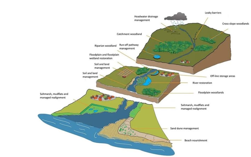
The concept of natural flood management involves implementing measures that can help to protect, restore and emulate the natural functions of catchments, floodplains, rivers and the coast.
Natural flood management works best when a ‘catchment-based approach’ is taken, where a plan is developed to manage the flow of water along the whole length of a river catchment from its source to the sea. This way, natural processes can be used upstream and on the coast to complement engineered flood defences – such as walls and weirs – in populated areas.
Natural flood management not only reduces flood risk, it can also achieve multiple benefits for people and wildlife, helping restore habitats, improve water quality and helping make catchments more resilient to the impacts of climate change.
The image below illustrates the types of natural flood management that will be encouraged as part of a catchment-based approach. Find out more about a catchment-based approach.
Flooding
Somerset Council is the Lead Local Flood Authority as defined by the Flood and Water Management Act 2010 and Flood Risk Regulations 2009. For all information visit our Water Management webpage.
Phosphates
In light of a court judgement (known as Dutch N) Natural England advised all planning authorities in Somerset (the four previous district councils) that parts of the Somerset Moors and Levels are being affected by high levels of phosphates in the watercourses.
Natural England has advised that, in light of the unfavourable condition of the Somerset Levels and Moors Ramsar Site, before approving a planning application that may give rise to additional phosphates within the catchment risk area, competent authorities should undertake a Habitats Regulations Assessment. In practice, this means the Habitats Regulations Assessment for housing and other applications in the risk area will need to include a phosphate loading calculation and measures to reduce phosphates in water runoff and sewerage, so it becomes ‘nutrient neutral’. This is explained in the Natural England summary. A planning application will only be able to proceed to a positive recommendation if the proposed development is phosphate neutral or there is identified mitigation that can be secured.
Additional phosphate loading generally arises from the discharges from sewage treatment works and private package treatment works and sewage tanks, with agricultural development and anaerobic digesters also giving rise to specific issues. Increased loading can also arise as a result of surface water run-off from the changed use of land.
Affected Development:
The types of development subject to phosphates-related Habitats Regulations Assessment within the area of risk include:
- new residential units – including tourist accommodation, gypsy sites and pitches
- commercial developments – where overnight accommodation is provided
- agricultural development – additional barns, slurry stores and so on, where it is likely to lead to an increase in herd size
- anaerobic digesters
- possibly some tourist attractions
The Phosphorous Budget Calculator can be used for proposed developments across Somerset.
Waterless urinals
The former Somerset West and Taunton Council declared a Climate Emergency in February 2019 and worked with the former Somerset County Council and other district councils across the county to produce a county-wide climate emergency strategy. The district’s own carbon neutrality and climate resilience action plan sat alongside the strategy and included actions related to water-saving measures.
As one of the water-saving action points Somerset West and Taunton Council worked with industry leaders in waterless urinal technology, WhiffAway, to save water for public and private conveniences. The work involved installing special plumbing outlets, and housing chemically impregnated filters onto existing urinals. The filters rapidly neutralise any odours without the need for flushing.
On average, a single urinal uses 120 cubic meters of water a year, with much water being lost through automatic flushes when there is little to no footfall. The switch to a waterless system will result in significant water savings.
The following locations have switched over to waterless systems:
- West Somerset Railway Station in Bishops Lydeard
- Canon Street, Paul Street, Victoria Park and Vivary Park in Taunton
- North Street, Wellington Park and Deane Depot, Westpark in Wellington