Today we are issuing the final multi-agency update following the move to the recovery stage earlier this week.
The weather forecast remains changeable and water levels are still impacting on some local roads. Following the reopening of the A361 on the Levels yesterday (Thursday 19 February), there was fresh flooding to the road early this morning as a result of accumulated rain during the middle part of the week, causing the spillway once again to top over and the road had to be closed again today (Friday 20 February).
We anticipate this situation remaining in flux for the next few weeks until there is a sustained period of dry weather. As soon as it is safe for drivers the road will be reopened.
Meanwhile, pumping operations are continuing and water levels more generally are receding. See the Environment Agency update below for further details.
To view previous updates, visit the Council’s Newsroom archive.
We are encouraging anybody affected by flooding to please report it here:
Flood report – Self Service.
In an emergency residents should always call 999 immediately.
Environment Agency update
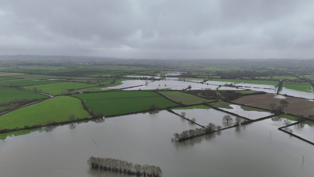
Our response continues across the Somerset Levels and Moors, and we are continuing to maximise every opportunity to move water off the moors.
Wednesday brought between 10-28mm of rain across Somerset, with river levels rising in response. As peak river flows passed through the Tone on Thursday, Hookbridge spillway started running again into Currymoor, which has subsequently caused Athelney Spillway to run.
Peak river flows have now passed through, and river levels are beginning to fall. Very little rainfall has been recorded in the last 24 hours, and we anticipate that conditions will slowly improve over the next two days, with low rainfall totals forecast. There is potential for more persistent rain on Sunday, and because the ground is fully saturated, catchments remain sensitive.
Pumps upstream of Burrowbridge, including Currymoor, West Sedgemoor, Huish Episcopi and Long Load, are currently inhibited by high river levels, but we will commence pumping again as soon as conditions allow. We have been able to operate pumps today at Westover and Midelney. We are monitoring conditions across the whole system 24 hours a day to remove water and reduce flood risk across the whole catchment as river conditions allow.
5 Flood Warnings and 8 Flood Alerts remain in place across Somerset. Our flood warnings contain the latest information about conditions near you, and we encourage people to check for updates. You can also monitor levels at our gauging stations at Find river, sea, groundwater and rainfall levels – GOV.UK.
Somerset Council are responsible for managing road closures – for the latest information: www.somerset.gov.uk/roads-travel-and-parking/emergency-road-closure-gates
There is further useful information on how the Levels and Moors operate in this document: How the Somerset Levels Work
What the Environment Agency is doing
- We have deployed additional pumps to 19 locations across the Somerset Levels and Moors. We have teams out throughout the day and night monitoring, servicing, refuelling and switching on pumps at every opportunity.
- The Tone and Parrett remain high following Thursday’s rainfall, which has inhibited upstream pumps. However, we are continuing to operate temporary pumps at Northmoor, Saltmoor, Dunball (on high tides only), the Bridgwater Canal, Elson’s Clyce and Westonzoyland. Stanmoor, Westover and Midelney pumping stations have also been able to run today.
- In the Parrett catchment, Monksleaze Clyce is open to divert flows into the Sowy relief channel.
- The station pumps at Northmoor and Saltmoor have been running throughout the event with very few inhibitions from high river levels. However, we cannot pump when river levels are too high, and the temporary pumps cannot run when there is not enough water in the drain. These conditions mean that the temporary pumps are occasionally paused. We have staff at the pumping stations 24 hours a day maximising opportunities to pump – all pumps are ready to run as conditions allow.
- In the Brue catchment, station pumps and extra pumps are operating at North Drain Pumping station; these extra pumps have been operational for the past 10 days, running as and when Brue levels allow. When the Brue is high from either high tides or water coming down the catchment, it limits our ability to pump from the North Drain. We continue to use the Cripps diversion.
Advice for communities
For safety reasons, people are advised not to walk or drive through floodwater, which may be deeper than it appears and could contain sewage and hidden hazards.
Anyone experiencing property flooding is encouraged to report it as soon as possible, as this helps organisations coordinate support and prioritise response efforts. Reports can be made via the EA Incident Hotline on 0800 80 70 60.
Sign up to flood warnings to receive by text, phone or email, or call Floodline to sign up to flood warnings, find out what is happening near you, and get advice on 0345 988 1188 or textphone on 0345 602 6340.
For welfare needs, including animal welfare, contact Somerset Council on 0300 123 2224.
Find more information and local gauge levels via GOV.UK’s Find river, sea, groundwater and rainfall levels page.
Further useful information can be found in the EA’s How the Somerset Moors work document.
Highways and transport
Damage to roads
Countywide, the recent weather has caused a high number of defects on roads across Somerset, and teams are working hard to assess and fix these in order of priority.
If you spot a problem, please report it as soon as possible via the Council’s Report a problem on the road page. This is the quickest route for incidents to get picked up.
People are reminded to be patient during this time, as urgent repair work may result in travel disruption, and their understanding is valued.
Current road closures due to flooding and adverse weather
On the Levels, the emergency road closure gates remain closed on the A361 between Burrowbridge and East Lyng, Cutts Road, the Langport to Muchelney Road, and New Road, West Lyng.
Please do not ignore road closure signs.
Also:
- Aller Drove, Wetmoor Lane and Thorney Road near Langport; Godney Road from B3151 to Godney Drove crossroads; Ruggs Drove, Chedzoy.
- Red Hill, Oath, Curry Rivel; Wickmoor, Wick, Curry Rivel
- A30 Hendford Hill, Yeovil is currently closed due to fallen trees/bank slippage. Teams are working hard to reopen the road as soon as possible.
Please check the Council’s Roadworks and travel information page and follow @TravelSomerset on X (formerly Twitter) and Facebook for live travel updates, roadworks and other highways news.
NHS Somerset update
NHS Somerset remains available to support anyone who needs help with their health during this difficult time.
- For advice on health conditions or to check symptoms, individuals can visit nhs.uk or call 111.
- Those needing clinical advice about a developing health condition can call 111, where clinicians can provide guidance and arrange a call‑back if required.
- Somerset has 90 community pharmacies with highly experienced pharmacists who can offer clinical advice on more than 40 common conditions and provide prescriptions for 7 common conditions, including eye infections and UTIs, as part of the Pharmacy First service.
- The local mental health service offers a 24/7 helpline, also available online during daytime hours. The service can be reached via Mindline Somerset on 0800 138 1692 (freephone) or 01823 276892 (local rate).
- Urgent treatment centres across Somerset are available to help with urgent care needs, including sprains, broken bones, head injuries, bites, eye infections, and chest and throat infections. These centres are located in Frome, Glastonbury, Shepton Mallet, Chard, Bridgwater, Minehead (Minor Injury Unit), and Yeovil.
For more detailed information on how the NHS in Somerset can support residents this winter – including access to warm hubs, pain cafés, free food support, domestic violence assistance, and financial help – individuals can visit the NHS Somerset winter webpages.
Preparing for flooding
- Sign up for flood warnings at gov.uk/get-flood-warnings
- Call Floodline on 0345 988 1188 for updates, to sign up for warnings, or to report flooding
- Visit gov.uk/prepare-for-flooding or somersetprepared.org.uk for advice on what to do during a flood
- Call 999 if there is a risk to life
Report flooding to:
- EA (main rivers or sea): 0800 80 70 60
- Somerset Council (ordinary watercourses): 0300 123 2224
- Wessex Water (sewers): 0345 600 4600
Check for flooding updates at check-for-flooding.service.gov.uk.
Visit gov.uk/help-during-flood or somersetprepared.org.uk for guidance.
Advice for residents
The Council’s Communications Team is sharing information about where to find useful information for what to do to prepare for flooding.
Anyone worried about flooding or impacted by flooding can find advice and guidance via the Council’s Flooding information and advice page.
Anyone needing to leave their home due to flooding is reminded to take any medication they may need with them.
Do not drive through flood water. More information about safety during floods on the road can be found on Somerset Road Safety’s Adverse weather conditions page.
Reporting problems
To report flooding on a road or blocked drains on a road, use the report a problem on a road form.
If your property is owned by the Council and has been affected by flooding, please visit the Housing repairs page or call 0300 123 2224.
For urgent housing needs, contact the Housing Team on 0800 123 2224. Further information can be found on the Homelessness guidance page.
Stay up to date
For the latest travel updates, follow @TravelSomerset on Facebook, X (formerly Twitter) or visit the Roadworks and travel information page.
Find out the current status of roads that have Emergency road closure gates.